We pulled into the Gettysburg National Military Park at
about 4:15 on a Monday afternoon, only to find the perfect way for us to tour
the area- by bike. I remember going with
my dad when I was about 12. Tour guides
then, as now, are trained and certified by the national park. Almost everyone tours either by bus, or gives
their keys to a guide for a personal auto tour (which my family did in our VW
bus way back when). The bike tour
outfit is set up in the RV lot. We have
our own bikes, but there are plenty to rent as well. I reserved the afternoon tour- more
battlefield, more park roads, less traffic.
Ahh, exercise!
 |
| Monuments everywhere- near the peach orchard |
 |
| The view from Little Round Top |
There are monuments everywhere, for every unit, on both
sides of the battle. There are even
markers as to where one regiment ended and another began. A very sobering place.
One of Rebecca’s picks was to hike on the Appalachian Trail,
so we made plans to go on a guided hike on “family day”. Unfortunately, they cancelled the hike. Fortunately, the AT cut right through our
campground at Caledonia State Park in Pennsylvania. Another bonus- we would be able to see an AT “shelter”
nearby, where “through hikers” (not us…) can stay the night. The plan was to hike to the shelter, the turn
around so we could get on the road to our next destination. I studied the AT map on line, and brought the
hiking guide provided by the park with us.
Becca wanted to keep going after the shelter, and after consulting the
hiking guide, we chose a path. The guide
was not completely accurate… We had
already PASSED the turn off on our chosen path, so our 3 mile hike turned into
a 3 hour tour. Becca and I bore some resemblance
to a dry land Gilligan and Skipper.
Thank goodness for cell phones and GPS!
We did see the best shelter any through hiker had ever seen, and a
gorgeous rhododendron tunnel. We also
had plenty of time all by ourselves to talk more about birds, bees.... and how
the sun helps you tell time of day and direction.
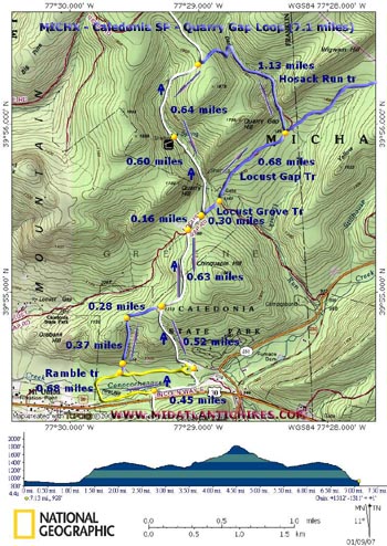 |
| This is the map I wish I had printed out... |
Robin… One more bit of excitement that Becca thankfully
slept right through. 2AM the night
before our bike tour, someone starts banging on the RV yelling, “Can anyone
tell me the way to the main road?!!?
They said to turn right at the stop sign!!” Now there were only 2 RVs and 3-4 tents in
this park. The main road was to the
right of the stop sign. I think the poor
tenters gave her that advice. She woke me out of a dead sleep. My first reaction was that someone needed
help, so I profoundly said, “WHAT?”, and
stumbled out of bed. Then she said the
courts ruled against the Pope, and she was part Native American, and why can’t
anyone tell her how to get to the main road?!!
With that, she quickly established herself as a 911 candidate. Thanks to the Appalachian Trail map- the good
one that I didn’t have on the hike- I remembered what county we were in. It took the State Police 911, then the county
911, about 5 seconds to say- “That sounds like Robin. Someone is on the way- it’ll be about 20
minutes”.
“Should I keep
talking to her to keep her here?”
“No, don’t put yourself in any danger”.
It was hard to not do anything else, but that last statement
kept me quiet and inside. Sure enough,
15 minutes later headlights came up the road, and some calm voices got Robin
settled and out of the cold.
We’ve been praying for Robin and others as we not only see
the USA, but also people we don’t usually come across in our little Hudson,
Ohio “bubble”.
No comments:
Post a Comment